
 Latest images
Barometric pressure hits record low in Minnesota
2 posters

 Barometric pressure hits record low in Minnesota
![]() by TexasBlue Tue Oct 26, 2010 6:24 pm
by TexasBlue Tue Oct 26, 2010 6:24 pm
Barometric pressure hits record low in Minnesota
Associated Press
October 26, 2010
MINNEAPOLIS (AP) - A massive windstorm moving over the Midwest has set an unofficial record in Minnesota.
National Weather Service meteorologist Chris Franks says the barometric pressure sank to 28.41 inches in Aitkin on Tuesday morning, the lowest in the state since Nov. 10, 1998.
Franks says the area of lowest pressure is somewhat like the eye of a hurricane in that the winds are strongest some distance away from it.
On Tuesday morning, he says areas of southern and western Minnesota were experiencing wind gusts of more than 40 mph, with a high of 59 mph recorded near the North Dakota border.
Franks says he expects the pressure at the center of the storm will keep dropping Tuesday and move north, bringing the buffeting winds to the Twin Cities in the afternoon.

TexasBlue

MSP down to 1 runway, causing average delays of up to 4 hours
![]() by TexasBlue Tue Oct 26, 2010 6:29 pm
by TexasBlue Tue Oct 26, 2010 6:29 pm
MSP down to 1 runway, causing average delays of up to 4 hours
Bill McAuliffe and Paul Walsh
Minneapolis Star Tribune
October 26, 2010
A massive storm whipping up high winds across the Midwest has reduced Minneapolis-St. Paul International Airport to one working runway, causing average delays of up to four hours.
“It’s been a long, slow afternoon,” said airport spokesman Patrick Hogan. The airport was receiving 24 flights an hour, down from a normal average of 60.
Delays are expected to continue well into the evening, in part because similar weather-related slowdowns in other cities, including Chicago’s O’Hare International Airport. The weather also spawned a tornado that injured two people in Wisconsin, and led to the next-to-last Midtown Farmers’ Market in Minneapolis to be canceled.
In North Dakota, blizzard warnings were posted for Tuesday night with the possibility of 10 inches of snow, and a wind gust of 59 mph was recorded along the North Dakota-Minnesota border. A winter storm warning was also posted for much of northwest Minnesota, where 1 to 3 inches of wind-driven snow was expected to accumulate through Wednesday.
A strengthening low-pressure system is behind the sustained wind speeds of 30 to 40 miles per hour and gusts of up to 60 miles per hour, according to the National Weather Service.
Shortly before 3 p.m., the National Weather Service reported winds in the Twin Cities out of the southwest at 23 miles per hour, with gusts up to 40 mph. To the west, gusts of 50 mph or more were reported in Olivia, Morris and Glenwood, Minn.
Come nightfall, the wind speeds will taper a bit, the Weather Service adds, before cranking up again Wednesday morning.
The high-wind warning is in effect until 7 p.m. Wednesday.
In Minnesota, a record was set for the lowest ever barometric pressure reading.
In Wisconsin, the National Weather Service confirmed that a tornado caused two minor injuries, uprooted trees and damaged buildings in southern Wisconsin.
Weather Service forecaster Mark Gehring told reporters in Racine County Tuesday that the tornado is rated as an F1, the weakest possible twister with winds in the 86 to 105 mph range.
Two workers at the Case tractor plant in Mount Pleasant suffered minor injuries when the storm ripped off a 200-by-100-foot section of roof.
Meanwhile, much of North Dakota was expecting its first significant snowfall of the season. The National Weather Service issued a blizzard warning, saying up to 10 inches of snow could fall in some areas into early Wednesday.
The snow is expected across North Dakota and into northern South Dakota. Forecasters said wind gusts of more than 50 mph in many areas would make travel treacherous.
The storm — quickly nicknamed a “chiclone” and “windpocalypse” — swept an area that stretched from the Dakotas to the eastern Great Lakes. Severe thunderstorm warnings blanketed much of the Midwest and tornado watches were issued from Arkansas to Ohio. Flights were delayed at O’Hare, a major hub for American and United airlines.
Sustained winds of 35 to 40 mph and gusts up to 60 mph were expected throughout the afternoon, the National Weather Service said.
Wind speeds in Minnesota were expected to pick up in the afternoon before tapering off at night and picking up again on Wednesday.
Meteorologist Amy Seeley described the storm as one of the worst in decades based on a reading of the pressure level at its center, which was similar to a Category 3 hurricane — although the effects of the storm were not. The wind gusts were only as strong as a tropical storm; Category 3 hurricanes have winds from 111 to 130 mph.
“This is a very different type of event,” said Edward Fenelon, a National Weather Service meteorologist in Romeoville, Ill. “But that does give an indication of the magnitude of the winds. This isn’t something you see even every year.”
The winds blew off roofs at a tractor plant in Mount Pleasant, Wis., and a home in Peotone, Ill.
Sheryl Uthemann, 49, of South Milwaukee, was working first shift at the Case New Holland plant in Mount Pleasant when the storm blew through about 8 a.m. and started to lift up the roof.
“It was just a regular work day and all of a sudden that noise just came and (co-workers) said 'Run! Run! Run!’ You didn’t have time to think,” she said. “I looked up where the noise was coming from and saw pieces of the roof sucked up. I’ve never been more scared, ever.”
Commuters in the Chicago area faced blustery, wind-driven rain as they waited for trains to take them downtown before dawn. Some huddled beneath train overpasses to stay out of the gusts, dashing to the platform at the last minute. In the city’s downtown Loop, construction workers wore heavy rain coats and held onto their hard-hats, heavy metal streets signs rattled against their posts and umbrellas provided relief only for as long as they could last.
“The wind was almost blowing horizontally. The rain was slapping me in the face,” said Anthony Kwit, a 24-year-old jewelry store worker in Chicago. “My umbrella shot off ... It was pretty dangerous.”
He said the wind was so strong that his car “was starting to veer off the road.”
Another commuter described a frightening pre-dawn drive to the train station.
“It was raining really, really hard. Coming down the street I was kind of getting really nervous; even with the bright lights you couldn’t see in front of you,” said Delphine Thompson, 53, a telecom manager in Chicago.
The weather service said gusts that topped 50 miles per hour slammed into the Chicago suburb of Lombard early Tuesday.
Federal Aviation Administration spokesman Tony Molinaro said that flights were delayed early Tuesday morning at O’Hare because the airport was able to use only two runways for arrivals and one for departures. By mid-morning, the delays were down to 15 to 30 minutes, he said.
Indianapolis International Airport also reported some flight delays.
The storm also picked up speed on Twitter, where people dubbed it “Chiclone” and “Windpocalypse.”
In St. Louis, pre-dawn strong winds were blamed for a partial building collapse that sent bricks, mortar, roofing and some window air conditioning units raining down onto a sidewalk. No one was injured, and inspectors were inspecting the 1920s-era building.
In Ballwin, a St. Louis suburb, a woman escaped with minor injuries when a tree fell onto her home as she slept, covering her and her husband with dust and insulation. The family managed to get out of the house and call emergency responders.
In Milwaukee, some restaurants moved sidewalk furniture indoors as the storm approached and homeowners scrambled to batten down anything that might be swept away by the storm.
Utilities in Indiana, Illinois and the St. Louis area said more than 80,000 homes and businesses were without power.
Fenelon of the National Weather Service said the winds will subside Tuesday evening but could pick up again on Wednesday.
Eleven states are under a high wind warning: Illinois, Wisconsin, Indiana, Iowa, Michigan, North Dakota, South Dakota, Nebraska, Minnesota, Ohio and parts of Kentucky.
TexasBlue
Re: Barometric pressure hits record low in Minnesota
![]() by i_luv_miley Tue Oct 26, 2010 9:28 pm
by i_luv_miley Tue Oct 26, 2010 9:28 pm
I'm sort of a weather-buff and while looking at the National Weather Service website, I saw some barometric pressures northwest of Minneapolis around 28.2 inches. That totally blew me away (literally)! Pressures of 29.5 inches are considered low and when you get below 29 inches, you're talking hurricane-level pressures (and possibly hurricane winds). So 28.2 inches is just psychotic to me.  By contrast, Hurricane Ike in 2008 (which just happened to pass about fifteen miles east of where I am) had a pressure of around 29 inches. So, technically, this storm is much more powerful.
By contrast, Hurricane Ike in 2008 (which just happened to pass about fifteen miles east of where I am) had a pressure of around 29 inches. So, technically, this storm is much more powerful. 
i_luv_miley
- Birthday : 1969-07-14
Age : 54
Re: Barometric pressure hits record low in Minnesota
![]() by TexasBlue Tue Oct 26, 2010 9:41 pm
by TexasBlue Tue Oct 26, 2010 9:41 pm
i_luv_miley wrote:I'm sort of a weather-buff and while looking at the National Weather Service website, I saw some barometric pressures northwest of Minneapolis around 28.2 inches. That totally blew me away (literally)! Pressures of 29.5 inches are considered low and when you get below 29 inches, you're talking hurricane-level pressures (and possibly hurricane winds). So 28.2 inches is just psychotic to me.
Pressure here where I am (2 and a half hours from Minneapolis) is 28.76.
Wind is 31 mph with gusts to 45.
Temp is 35 °F with light snow. Windchill? 21 °F

They explained today in the paper about the difference between this and a hurricane.
It's more temp related along with the jet stream than warm water (obviously).Air normally rushes into low pressure like water into a funnel, said NWS meteorologist Chris Franks. In this case, contrasting temperatures across the region, typical for spring and fall, will squeeze the low pressure center, forcing circulating winds into a tighter rotation.
As in a hurricane, winds near the center, in the Duluth region, will be moderate Wednesday, while they'll be howling from the northwest in western and southern Minnesota.
TexasBlue
Re: Barometric pressure hits record low in Minnesota
![]() by i_luv_miley Tue Oct 26, 2010 9:46 pm
by i_luv_miley Tue Oct 26, 2010 9:46 pm
According to the net, it's 82 degrees here right now.TexasBlue wrote:Temp is 35 °F with light snow. Windchill? 21 °F
 The high today was around 90.
i_luv_miley- Birthday : 1969-07-14
Age : 54
Re: Barometric pressure hits record low in Minnesota
![]() by TexasBlue Tue Oct 26, 2010 9:49 pm
by TexasBlue Tue Oct 26, 2010 9:49 pm
i_luv_miley wrote:According to the net, it's 82 degrees here right now.TexasBlue wrote:Temp is 35 °F with light snow. Windchill? 21 °F
Better me than you. Oh. Wait a damn minute here!

Radar... check it out. I'm northwest of St. Cloud.
http://www.accuweather.com/us/radar/sir/mn_/radar.asp?play=true
TexasBlue
Re: Barometric pressure hits record low in Minnesota
![]() by TexasBlue Wed Oct 27, 2010 9:39 am
by TexasBlue Wed Oct 27, 2010 9:39 am
from the weather blogger in the Minneapolis paper............
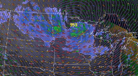
October Superstorm. Lowest Pressure On Record For The USA. Welcome to the Land of 10,000 Weather Extremes. Yesterday a rapidly intensifying storm, a "bomb", spun up directly over the MN Arrowhead, around mid afternoon a central pressure of 953 millibars was observed near Orr. That's 28.14" of mercury. Bigfork, MN reported 955 mb, about 28.22" of mercury. The final (official) number may be closer to 28.20-28.22", but at some point the number becomes academic. What is pretty much certain is that Tuesday's incredible storm marks a new record for the lowest atmospheric pressure ever observed over the continental USA. That's a lower air pressure than most hurricanes, which is hard to fathom.
How did this happen, especially coming after 4 dry, mild, unusually sunny & quiet weeks/row? Generally speaking, the larger the "baroclinicity" (the north-south temperature contrats across N. America) the greater the potential for an epic storm to develop. Yesterday all the ingredients converged over Minnesota, an unusually powerful jet stream core (blowing at close to 200 mph 5-8 miles overhead). The approach of a "jet streak" aloft caused a partial vacuum to form over the MN Arrowhead, air rushing into this low pressure system accelerated to speeds as high as 60 mph, downing trees and powerlines, cutting off power to WeatherNation in Excelsior for a time during the evening hours.
* Shortly before 8 am Tuesday the barometric pressure fell to 28.61" in the Twin Cities. That's the second lowest pressure ever observed at MSP, according to NOAA.
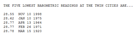
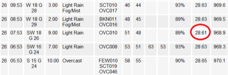
Twin Cities Data. Shortly before 8 am Tuesday the pressure dropped to 28.61" at MSP, making this the second lowest air pressure ever recorded in the Twin Cities.
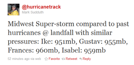
Redefining Low Pressure. 953 millibars near Orr, roughly 28.22" Tuesday afternoon. Only Hurricane Ike was stronger, at 951 mb. Tuesday's October Mega-Storm was stronger than Hurricane Gustav, Frances and Isabel. Thanks to Mark Sudduth for an unbelievable "tweet"!
October Superstorm. Lowest Pressure On Record For The USA. Welcome to the Land of 10,000 Weather Extremes. Yesterday a rapidly intensifying storm, a "bomb", spun up directly over the MN Arrowhead, around mid afternoon a central pressure of 953 millibars was observed near Orr. That's 28.14" of mercury. Bigfork, MN reported 955 mb, about 28.22" of mercury. The final (official) number may be closer to 28.20-28.22", but at some point the number becomes academic. What is pretty much certain is that Tuesday's incredible storm marks a new record for the lowest atmospheric pressure ever observed over the continental USA. That's a lower air pressure than most hurricanes, which is hard to fathom.
How did this happen, especially coming after 4 dry, mild, unusually sunny & quiet weeks/row? Generally speaking, the larger the "baroclinicity" (the north-south temperature contrats across N. America) the greater the potential for an epic storm to develop. Yesterday all the ingredients converged over Minnesota, an unusually powerful jet stream core (blowing at close to 200 mph 5-8 miles overhead). The approach of a "jet streak" aloft caused a partial vacuum to form over the MN Arrowhead, air rushing into this low pressure system accelerated to speeds as high as 60 mph, downing trees and powerlines, cutting off power to WeatherNation in Excelsior for a time during the evening hours.
* Shortly before 8 am Tuesday the barometric pressure fell to 28.61" in the Twin Cities. That's the second lowest pressure ever observed at MSP, according to NOAA.
Twin Cities Data. Shortly before 8 am Tuesday the pressure dropped to 28.61" at MSP, making this the second lowest air pressure ever recorded in the Twin Cities.
Redefining Low Pressure. 953 millibars near Orr, roughly 28.22" Tuesday afternoon. Only Hurricane Ike was stronger, at 951 mb. Tuesday's October Mega-Storm was stronger than Hurricane Gustav, Frances and Isabel. Thanks to Mark Sudduth for an unbelievable "tweet"!
TexasBlue
Re: Barometric pressure hits record low in Minnesota
![]() by i_luv_miley Wed Oct 27, 2010 7:48 pm
by i_luv_miley Wed Oct 27, 2010 7:48 pm
I didn't think Ike was that low. But 953 mb is amazing! Of course, I guess we're seeing the flip-side here (i.e. the warm side). We were in the 90's yesterday and we were in the 90's again today with a record high. But it's always hot and crappy here.  Apparently the actual "cold" is supposed to get here sometime tomorrow though. Lows on Friday are predicted to be in the 40's. So that'll make a nice change.
i_luv_miley- Birthday : 1969-07-14
Age : 54
Re: Barometric pressure hits record low in Minnesota
![]() by TexasBlue Wed Oct 27, 2010 7:54 pm
by TexasBlue Wed Oct 27, 2010 7:54 pm
i_luv_miley wrote:I didn't think Ike was that low. But 953 mb is amazing! Of course, I guess we're seeing the flip-side here (i.e. the warm side). We were in the 90's yesterday and we were in the 90's again today with a record high. But it's always hot and crappy here.
That Ike reading was at landfall. It's lowest reading was 935 mbar (27.61).
Texas is always warm and always has been. That's why it's a wasteland in the western part of the state.
It snowed here overnight. Maybe an inch. Wet, sloppy stuff. All gone now.
TexasBlue
Re: Barometric pressure hits record low in Minnesota
![]() by i_luv_miley Thu Oct 28, 2010 3:04 pm
by i_luv_miley Thu Oct 28, 2010 3:04 pm
Actually, scenery (or the lack thereof) aside, I'll take west Texas over this part any day. It's a "wasteland" because it's a lot drier than it is here. But I'm originally from New Mexico, which is considerably drier than even west Texas. It's a desert. But it's also high in altitude, which makes for some interesting weather. It can literally be 90 during the day and 40 at night. And because of the dryness, it's always comfortable no matter what the temperature. Texas, especially the eastern half, will never see that. It's always hot because it's always too freaking humid!TexasBlue wrote:i_luv_miley wrote:I didn't think Ike was that low. But 953 mb is amazing! Of course, I guess we're seeing the flip-side here (i.e. the warm side). We were in the 90's yesterday and we were in the 90's again today with a record high. But it's always hot and crappy here.
That Ike reading was at landfall. It's lowest reading was 935 mbar (27.61).
Texas is always warm and always has been. That's why it's a wasteland in the western part of the state.
It snowed here overnight. Maybe an inch. Wet, sloppy stuff. All gone now.
i_luv_miley- Birthday : 1969-07-14
Age : 54
Re: Barometric pressure hits record low in Minnesota
![]() by TexasBlue Thu Oct 28, 2010 4:31 pm
by TexasBlue Thu Oct 28, 2010 4:31 pm
i_luv_miley wrote:Actually, scenery (or the lack thereof) aside, I'll take west Texas over this part any day. It's a "wasteland" because it's a lot drier than it is here. But I'm originally from New Mexico, which is considerably drier than even west Texas. It's a desert. But it's also high in altitude, which makes for some interesting weather. It can literally be 90 during the day and 40 at night. And because of the dryness, it's always comfortable no matter what the temperature. Texas, especially the eastern half, will never see that. It's always hot because it's always too freaking humid!
You're right on. But Texas is a hot state no matter how one spins it. But the varying degrees of heat or humidity (or lack of) differs.
It's amazing how much people even mis-characterize Minnesota. I've met people in Texas (when I lived there) who thought it was cold all year round; that there was snow here all year round. People have no clue and need to get out more often.
 By the same token, there's people in Texas who didn't believe me when I told them that you can ice fish in the winter here. They didn't believe that you could drive a pickup truck out onto the lake. I had to take pix to prove it one year when I came home for Xmas.
TexasBlue

 Similar topics
» Dallas-Fort Worth hits record high for third straight scorching day
» Dewpoint (humidity level) in Twin Cities breaks record
» Democrats must decide whether to stand aside in Rangel case or exert pressure to end it
» Under pressure from Congress, Postal Service to delay major closings, layoffs until mid-May
» Tornado hits Minneapolis
» Dewpoint (humidity level) in Twin Cities breaks record
» Democrats must decide whether to stand aside in Rangel case or exert pressure to end it
» Under pressure from Congress, Postal Service to delay major closings, layoffs until mid-May
» Tornado hits Minneapolis
Permissions in this forum:
You cannot reply to topics in this forum